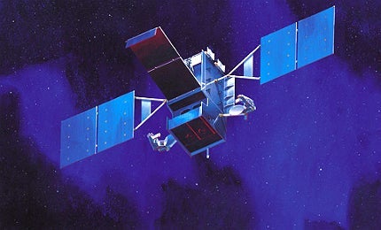
The space-based infrared system (SBIRS) is being developed to provide missile detection and warning capabilities for US defence forces. SBIRS satellites will replace the capabilities delivered by the defence support programme (DSP) satellites.
SBIRS will comprise of six satellites in geosynchronous orbit (GEO), four payloads in highly elliptical orbit (HEO) and a ground-based component used for data processing and control. The SBIRS system meets critical needs in key areas, including missile defence, missile warning, battlespace awareness and technical intelligence. The programme is currently in its implementation stage.
HEO-1 and HEO-2, the first two payloads in the series, are currently in orbit and providing infrared information from space. The GEO-1 satellite was launched in May 2011 and GEO-2 was launched in March 2013.
The SBIRS system is operated by the Air Force Space Command. Lockheed Martin Space Systems is the main contractor involved in the development.
US Strategic Command (USSTRATCOM) certified the HEO-2 payload and associated ground systems for missile warning operations in August 2009. The HEO-1 received similar certification in December 2008.
SBIRS orders and deliveries
In June 2009, the US Air Force awarded a $1.5bn contract to Lockheed Martin for the HEO-3 payload, GEO-3 satellite and ground modifications for the SBIRS constellation.
Lockheed Martin received a $262.5m down payment from the US Air Force in July 2009 for the fourth SBIRS GEO satellite. Furthermore, Lockheed Martin received an $82m contract to start work on the fifth and sixth geosynchronous (GEO) satellites, in October 2012.
The US Air Force awarded a $284.4m contract to Lockheed Martin in March 2013, for procuring the long lead parts of the GEO-5 and GEO-6 satellites under the SBIRS programme.
Features of the space-based infrared system
The US Department of Defense (DoD) began the SBIRS programme in 1996 to replace the existing missile detection system, and meet the needs of support intelligence, surveillance, and reconnaissance missions. Initially, it was estimated that the project could be completed by 2004 at a cost of $4.2bn.
In 1996, the DoD awarded a $2.16bn joint contract, for the SBIRS, to Lockheed Martin and Northrop Grumman, with the former being the lead contractor. However, during the past 13 years, the project continued to struggle with overriding costs and the Nunn-McCurdy limits of defence programme budget. The current expected SBIRS cost is more than $11bn.
Initially it was planned that SBIRS would have SBIRS high and SBIRS low-orbiting components. But in 2001, the air force transferred SBIRS low to the Missile Defense Agency (MDA). The MDA has renamed SBIRS low as the space tracking and surveillance system (STSS) to suit its missile defence needs. SBIRS high is now known simply as SBIRS.
The DoD commissioned a study, known as ARGUS, to examine options to fill coverage gaps if DSP satellites fall out of orbit before SBIRS satellites are fully operational.
Lockheed Martin Space Systems, the main contractor, is providing systems engineering and programme management, and is also involved in spacecraft development. The payload subcontractor, Northrop Grumman Electronic Systems, is responsible for supports systems engineering and ground mission processing development. LM Integrated Systems and Solutions is developing ground systems and support systems engineering.
BAE Systems will supply large-area staring and scanning photovoltaic infrared chip assemblies for the SBIRS early warning missile launch detection systems.
Geosynchronous orbit (GEO) series satellites
GEO-1 is the first satellite in GEO series. The payload has a staring sensor, scanning sensor, spacecraft subsystems and a pointing and control assembly (PCA). The scanning sensor performs surveillance and observation of intercontinental ballistic missile threats. The staring sensor can detect short-burn-duration theatre missiles of very low signature. The two focal planes in both sensors have around one million detector elements.
A new flight software subsystem installed in GEO-1 enables the spacecraft’s operation, control and monitoring while carrying out critical functions, such as telemetry, thermal control, power management and fault detection and recovery. GEO-1 had also undergone thermal vacuum testing in a flight-like environment. It was successfully launched in May 2011.
GEO-2, the second satellite in the series was launched in March 2013. The integration and safe-to-mate testing was completed in 2012.
After the completion of payload and bus integration, the satellite underwent through system-level environmental and acceptance testing. The GEO-3 satellite meets critical missile detection and surveillance needs.
Highly elliptical orbit (HEO) series satellites
Revolving in its highly elliptical orbit enables the HEO payload to detect ballistic missiles launched from northern Polar regions. Sensors equipped in HEO are similar to those of GEO.
In July 2009, The US Air Force accepted HEO-2 payload and ground system modifications from Lockheed Martin for operations. Lockheed Martin will also design the HEO-3 and HEO-4 payloads, which will meet critical missile detection and surveillance needs, as in the case of the GEO-3.
SBIRS ground station
The ground system manages transition, launch and mission operations for SBIRS GEO satellites and HEO payloads, and also supports on-orbit operations for the DSP satellites. The mission control station (MCS), located at Buckley Air Force Base, receives the data from the relay ground stations, which extract data from the satellites.
Key functions of the ground system for the SBIRS satellites include, mission planning, reporting, data distribution, constellation management and ground control.
Related content
Telstar 14R Telecommunications Satellite, United States of America
The Telstar 14R is a telecommunication satellite used to render mobile communication and digital broadband services to America, Brazil and North and Mid-Atlantic Ocean regions. It is the second mobile communication spacecraft in the Telstar fleet.
Wideband Global SATCOM (WGS) Satellite, United States of America
The wideband global SATCOM (WGS) system, previously known as the wideband gapfiller satellite system, is a high-capacity communication satellite.


