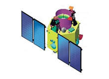
Earth observation satellite CARTOSAT-2A was launched from the Satish Dhawan Space Centre (SDSC), Sriharikota (SHAR) in India on 28 April 2008. It is the 13th Indian remote sensing satellite developed, launched and maintained by the Indian Space Research Organisation (ISRO), and one of three variants of the CARTOSAT series, the other two being CARTOSAT-1 and CARTOSAT-2.
The CARTOSAT-2A satellite was principally developed for the Indian military forces to monitor the missile launches of Pakistan and China by using high-quality images. India is the second country in Asia to have this state-of-art capability; the first being Japan.
The CARTOSAT-2A is an advanced and rugged remote sensing satellite equipped with a panchromatic camera (PAN). It can capture black and white images within the electromagnetic spectrum. The satellite’s PAN provides spatial resolution of more than 1m and swath of 9.6km.
The images offered by the camera are used for various cartographic applications, which encompass water resources, mineral prospecting, environment, forestry, drought and flood forecasting, ocean resources, mapping, developing and managing towns and city’s infrastructure, land information system (LIS) and geographical information system (GIS).
The CARTOSAT-2A satellite weighs 690kg and can transfer data at the rate of 105Mbit/s after compression. The lifespan of the satellite is five years. The satellite can be controlled 45° within or outside the track.
The configuration of the three CARTOSAT satellites makes them capable to study and display the changes occurring in the oceans.
CARTOSAT-2A earth observation satellite variants
The first of CARTOSAT series, CARTOSAT-1, was launched in May 2005. It is also the first remote sensing satellite in India.
CARTOSAT-2 was launched in January 2007 on a piggy-back of the PSLV-C7 rocket launcher. The variant comprises a 1m high-resolution camera with 120GB of memory for storing captured images.
CARTOSAT-2 is an advanced version that could capture images of up to 80cm resolution. The variant, however, has faced technical problems in the orbit affecting the quality of images.
An effort to overhaul the CARTOSAT-2 satellite led to the development of CARTOSAT-2A, a military version of the existing satellite. CARTOSAT-2A is also equipped with digital cameras that are more superior to those of CARTOSAT-1 and CARTOSAT-2 satellites.
PSLV-C9 satellite launcher
The CARTOSAT-2A was launched on a piggy-back of the PSLV-C9 launch vehicle. It is the third flight using ‘core alone’ version technology. The solid-state propellant, first-stage strap-on-motors were eliminated in this new version.
The PSLV-C9 launcher has the capacity to carry up to 230t of payload. For the launch, it carried ten payloads – the 690kg CARTOSAT-2A, an 83kg Indian mini satellite (IMS-1) and eight nano satellites weighing around 50kg.
The CARTOSAT-2A was successfully launched into space at a 97.94° inclination from the equator and telemetry data was received at the ground station on 2 May 2008.
Six of the eight nano satellites – CUTE 1.7, SEEDS, CAN-X2, AAUSAT-II, COMPASS-1 and DELPHI-C3 – were collectively named as NLS-4. The remaining two are known as NLS-5 and RUBIN-8. The NLS-4 was developed by the University of Toronto, Canada. NLS-5 and RUBIN-8 were built by the University of Toronto and Cosmos International, Germany.
The four-stage satellite launch took off from the second launch pad at SDSC, Sriharikota, with core ignition of the first stage and its separation. The second stage involved the separation of the heatshield at an altitude of 125km.
The fourth stage interposed the ten satellites into 635km polar sun synchronous orbit, 14 minutes after lift off. Soon after their launch into the orbit, the satellites automatically deployed their solar panels.
CARTOSAT-2A satellite payload
Israel’s synthetic aperture radar (SAR) has been installed in the CARTOSAT-2A to capture images of the earth through clouds and rain round-the-clock. The IMS-1 satellite incorporates advanced technologies and includes two remote sensing payloads – a multi-spectral camera (Mx Payload) and a hyper-spectral camera (HySI Payload). Both cameras function in visible and near infrared regions of the electromagnetic spectrum.
The multi-spectral camera has a spatial resolution of 37m and swath of 151km, whereas the spatial resolution and swath of the hyper-spectral camera are 506m and 130km.
The PAN camera covered Saharanpur to Nuh (South of Delhi) and Sangli to Goa coast in Western India, while the area from Uttarakhand to Karnataka via Delhi and Bhopal (north to south of India) is covered by a hyper-spectral camera.
CARTOSAT-2A ground station
The CARTOSAT-2A satellite is continuously monitored from the space control centre in Bangalore, using ISRO telemetry tracking and command (ISTRAC) network stations at Bangalore, India, Lucknow, Mauritius, Bearslake in Russia, Biak in Indonesia and Svalbard in Norway.
ISTRAC is equipped with independent and dedicated processors, which display real-time data of individual spacecraft missions. Off-line processors are used to manage spacecraft data archival, analysis and orbit determination.
In addition to ISTRAC, ISRO’s satellites are tracked through the telemetry tracking and command (TTC) system. The TTC systems allow the earth station to keep satellites in their orbits, without deviating from their original path.
The communication control facility at the ground station provides information sharing between the space control centre (SCC) and other external space centres via data, voice and TTC links.
The National Remote Sensing Centre (NRSC) is responsible for data acquisition, data processing, and data airing of remote sensing satellites. It is equipped with modern infrastructure for data analysis, advanced digital image processing (DIP) and with a GIS lab.


