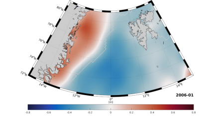
Researchers from the Technical University of Munich (TUM) have developed an algorithm for satellites that enables them to accurately determine the properties of oceans beneath the ice caps, which cannot be conventionally observed as the ice blocks them from the view of satellites.
The team published their findings in ‘ALES+: Adapting a homogenous ocean retracker for satellite altimetry to sea ice leads, coastal and inland waters’ in the journal Remote Sensing of Environment, which explains how oceans beneath the ice caps are obscured from view, and that observing and analysing the few cracks in the ice is insufficient.
“These patches of water are however very small and the signals are highly distorted by the surrounding ice,” said lead author Dr. Marcello Passaro of the TUM German Geodetic Research Institute.
“Here standard evaluation methods like those used for measurements made on the open seas are incapable of returning reliable results.”
The ALES+ (Adaptive Leading Edge Subwaveform) algorithm automatically identifies the portion of the radar signal that is reflected by water, and derives sea level values using only this information, making it possible to precisely measure the altitude of ocean water which reaches the surface through cracks in the ice. The algorithm focuses much like a virtual ‘contact lens’ that can sharpen the focus of the radar’s vision.
Researchers are now able to compare several years of measurements to draw conclusions about long-term changes in sea level and ocean currents.
“The special thing about our method is that it is adaptive,” said Passaro.
“We can use one and the same algorithm to measure sea level in both open and ice-covered ocean areas. ALES+ can also be used for coastal waters, lakes and rivers. Here the signals are highly varied, but always exhibit certain characteristic properties which the system then learns.”
The algorithm was tested in the Greenland Sea and was proved to be effective. The research is part of the European Space Agency’s Sea Level Climate Change Initiative.


