The aerospace and defence industry continues to be a hotbed of innovation, with activity driven by the pressing need for modernisation and the growing importance of emerging technologies such as artificial intelligence and unmanned systems. In the last three years alone, there have been over 174,000 patents filed and granted in the aerospace and defence industry, according to GlobalData’s report on Internet of Things in Aerospace, Defence & Security: Remote-controlled drone imaging. Buy the report here.

Discover B2B Marketing That Performs
Combine business intelligence and editorial excellence to reach engaged professionals across 36 leading media platforms.
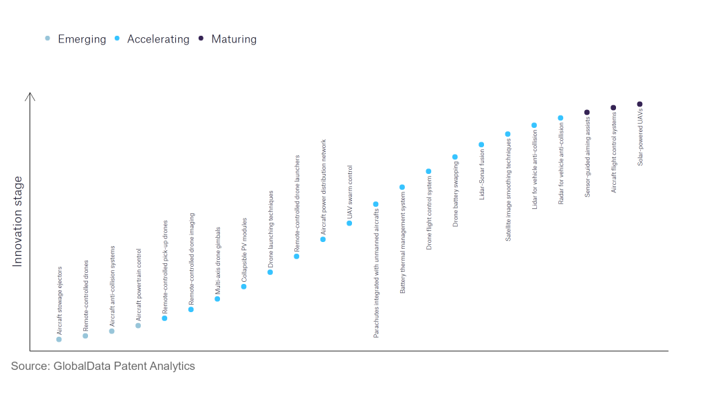
However, not all innovations are equal and nor do they follow a constant upward trend. Instead, their evolution takes the form of an S-shaped curve that reflects their typical lifecycle from early emergence to accelerating adoption, before finally stabilising and reaching maturity.
Identifying where a particular innovation is on this journey, especially those that are in the emerging and accelerating stages, is essential for understanding their current level of adoption and the likely future trajectory and impact they will have.
180+ innovations will shape the aerospace and defence industry
According to GlobalData’s Technology Foresights, which plots the S-curve for the aerospace and defence industry using innovation intensity models built on over 262,000 patents, there are 180+ innovation areas that will shape the future of the industry.
Within the emerging innovation stage, aircraft powertrain controls, remote controlled drones, and aircraft anti-collision systems are disruptive technologies that are in the early stages of application and should be tracked closely. UAV swarm control, lidar for vehicle anti-collision, and satellite image smoothing techniques are some of the accelerating innovation areas, where adoption has been steadily increasing.
Innovation S-curve for Internet of Things in the aerospace and defence industry

Remote-controlled drone imaging is a key innovation area in Internet of Things
Drones can be installed with imaging electrooptical (EO) or infrared (IR) sensors to allow them to be deployed in various roles such as surveying and ISR.
GlobalData’s analysis also uncovers the companies at the forefront of each innovation area and assesses the potential reach and impact of their patenting activity across different applications and geographies. According to GlobalData, there are 40+ companies, spanning technology vendors, established aerospace and defence companies, and up-and-coming start-ups engaged in the development and application of remote-controlled drone imaging.
Key players in remote-controlled drone imaging – a disruptive innovation in the aerospace and defence industry
‘Application diversity’ measures the number of different applications identified for each relevant patent and broadly splits companies into either ‘niche’ or ‘diversified’ innovators.
‘Geographic reach’ refers to the number of different countries each relevant patent is registered in and reflects the breadth of geographic application intended, ranging from ‘global’ to ‘local’.
Among aerospace and defence companies, Skydio is the leading patent filer in remote-controlled drone imaging. Skydio specialises in the development of drones purely for aerial imaging. The firm’s products, which include Skydio 2+ and Skydio X2, are offered for use in defence, public safety, and enterprise inspection roles. Other key patent filers include Israel Aerospace Industries, which produces UAVs such as Heron, which is capable of performing ISR missions for defence customers, and AeroVironment, which specialises in medium and small UAS and loitering munitions for defence clients.
In terms of application diversity, Israel Aerospace Industries leads the pack. Skydio and Teledyne Technologies stood in the second and third positions, respectively. By means of geographic reach, Thales holds the top position, followed by Israel Aerospace Industries and AeroVironment.
Remote-controlled drone imaging empowers unmanned platforms to perform a number of vital roles such as intelligence, surveillance and reconnaissance (ISR) and border surveillance. Given that drones are increasingly cheap, and typically less expensive than manned alternative, development of remote-controlled drone imaging offers aerial imaging to a wider range of customers.
To further understand how Internet of Things is disrupting the aerospace and defence industry, access GlobalData’s latest thematic research report on Thematic Research - Internet of Military Things.
Data Insights
From

The gold standard of business intelligence.
Blending expert knowledge with cutting-edge technology, GlobalData’s unrivalled proprietary data will enable you to decode what’s happening in your market. You can make better informed decisions and gain a future-proof advantage over your competitors.


